Kawai, Nara
Kawai
河合町 | |
|---|---|
 Kawai Town Hall | |
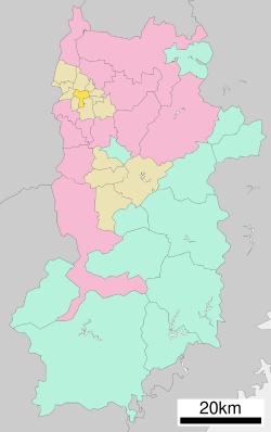
 Location of Kawai in Nara Prefecture | |
 | |
| Coordinates: 34°34′42″N 135°44′12″E / 34.57833°N 135.73667°E | |
| Country | Japan |
| Region | Kansai |
| Prefecture | Nara |
| District | Kitakatsuragi |
| Area | |
• Total | 8.23 km2 (3.18 sq mi) |
| Population (November 30, 2024) | |
• Total | 16,636 |
| • Density | 2,000/km2 (5,200/sq mi) |
| Time zone | UTC+09:00 (JST) |
| City hall address | 1-1 Ikebe, Kawai-cho, Kitakatsuragi-gun, Nara-ken 636-8501 |
| Website | Official website |
| Symbols | |
| Flower | Adonis |
| Tree | Camellia sasanqua |

Kawai (河合町, Kawai-chō) is a town located in Kitakatsuragi District, Nara Prefecture, Japan. As of 30 September 2024[update], the town had an estimated population of 16,636 in 7968 households, and a population density of 2000 persons per km2.[1] The total area of the town is 8.23 km2 (3.18 sq mi).
Geography
[edit]Kawai is located in the flatlands of northeast Nara Prefecture in the Nara Basin.
Surrounding municipalities
[edit]Climate
[edit]Kawai has a humid subtropical climate (Köppen Cfa) characterized by warm summers and cool winters with light to no snowfall. The average annual temperature in Kawai is 14.6 °C. The average annual rainfall is 1636 mm with September as the wettest month. The temperatures are highest on average in August, at around 26.7 °C, and lowest in January, at around 3.1 °C.[2]
Demographics
[edit]Per Japanese census data, the population of Kawai is as shown below
| Year | Pop. | ±% |
|---|---|---|
| 1940 | 5,470 | — |
| 1950 | 6,644 | +21.5% |
| 1960 | 6,546 | −1.5% |
| 1970 | 7,693 | +17.5% |
| 1980 | 15,793 | +105.3% |
| 1990 | 19,408 | +22.9% |
| 2000 | 20,126 | +3.7% |
| 2010 | 18,531 | −7.9% |
| 2020 | 17,018 | −8.2% |
History
[edit]The area of Kawai was part of ancient Yamato Province, and many kofun burial mounds are located within the town. From the 11th to the 14th century, the area was a shōen landed estate controlled by the temple of Tōdai-ji. The village of Kawai was established on April 1, 1889 with the creation of the modern municipalities system. It was elevated to town status on December 1, 1971.
Government
[edit]Kawai has a mayor-council form of government with a directly elected mayor and a unicameral town council of 12 members. Kawai, collectively with the other municipalities of Kitakatsuragi District, contributes three members to the Nara Prefectural Assembly. In terms of national politics, the town is part of the Nara 2nd district of the lower house of the Diet of Japan.
Economy
[edit]The local economy is based on agriculture and light manufacturing.
Education
[edit]Kawai has two public elementary schools and Two public junior high school operated by the town government and one public high school operated by the Nara Prefectural Board of Education. There is also one private high school.
Transportation
[edit]Railways
[edit]![]() Kintetsu Railway - Tawaramoto Line
Kintetsu Railway - Tawaramoto Line
 Ōwada - Samitagawa - Ikebe
Highways
[edit]Sister cities
[edit]Local attractions
[edit]- Nagareyama Kofun, National Historic Site
- Samida Takarazuka Kofun, National Historic Site
- Ōtsukayama Kofun Cluster, National Historic Site
References
[edit]- ^ "Kawai Town official statistics" (in Japanese). Japan.
- ^ Kawai climate: Average Temperature, weather by month
External links
[edit] Media related to Kawai, Nara at Wikimedia Commons
- Kawai official website (in Japanese)


